Perimeter Hike


To see more photos of from this hike go to: www.LCPhoto.SmugMug.com.
Hike Stats
Getting There
Turn-By-Turn
DownloadsRelated Hikes
|
Description and Map
This is a very versatile hike. It takes you around the perimeter of the park (thus the name) and allows access to most of the trails within the park as alternate routes or side trips. It's also great for those looking to work up to more challenging hikes as there are numerous cut-off points to shorten the length of the hike or to by pass steeper sections of the hike. It is a bit confusing as many of the signs are somewhat vague and the trails cross a lot.
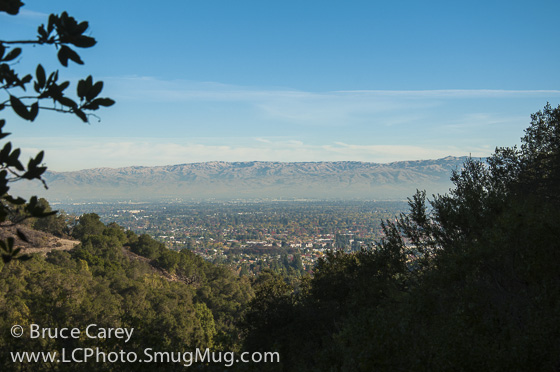
Opening Note: As of this initial writing I have only hiked this park in the Fall so I have no comments on Spring flowers. Hopefully I'll update this come spring. The hike starts with the ½ mile Cora Older trail, a medium width trail that immediately starts up a moderate incline. Through a series of switchbacks, the trail follows a ravine created by a creek of unknown name (dry in summer and fall). Most of the time is spent in stands of Oak that provide a shady place to walk. As you near the end of this trail the Oaks clear out and you enter the middle section of the park with its more open grasslands and patchy spots of Oak. The ascent continues in the open grasslands and after a short distance you enter the Seven Springs Loop Trail. This is a nice, mostly single track loop that descends to the lowest point of the hike with a fairly constant, moderate descent. The descent part of the trail travels through a dense, shady forest of several varieties of Oaks and Bayberries. In a few spots there is the pleasant surprise of ferns dotting the forest floor, a bit unusual at this low of an elevation. Further along on the trail some Maples begin to make an appearance and in the Fall their large yellow leaves make a good color show. Through the gaps in the trees can also be seen some early glimpses of the Silicon Valley around the Sunnyvale/Mountain View areas, a tantalizing preview of the more dramatic panoramas to come. The lowest elevation of the hike is fairly obvious as the trail levels for maybe 50 feet at the bottom of the ravine and immediately starts back up. This essentially follows one of my hiking caveats - "What goes down, must go up." At this point the forest cover opens up into more grasslands with patches of Oaks and even some EucalyptusThere are some occasional stretches through Oak forests . In the Fall there are some great dots of reds and oranges from some trees of a species unknown to me at present. As this section of trail is on the Valley side of the hills there are frequent views of the Valley. There are a few sections of fairly steep inclines in this section of the trail, but all are fairly short and alternate with more moderate climbs. There are several possible side trails you could take in this area. First is the Rainbow Knoll Trail and second is the Woodhills Loop. I have not yet explored these side trips so more on that when I do. Eventually the Seven Springs trail takes us back to the middle area of the park and merges with the Hayfield Trail. One final thought on the Seven Springs trail, I'm not really sure why it's called that as I have never seen any traces of even one spring, but I suppose there was some reason for the name at the time. Now on the Hayfield Trail, which at this point is a service road sized trail that follows the gently rolling hilly contours of the land, you are back in the sunny, grassy, open middle section of the park. After maybe ½ mile or so the trail begins a moderate climb into the tree covered hills that can be seen ahead. As you ascend the scrub vegetation gets more and more dense around the trail. (Someday I hope to get better at identifying the variety of shrubs in this common California landscape, but for now I just have to call it scrub.) Continuing on, the ascent begins to steepen a bit with some sections being moderately steep and moderately long. No problem though because stopping occasionally to "take in some nice views of the hills ahead and, if you turn around, some nice views of the Silicon Valley" is a great excuse to take a break! Keep an eye out to the right of the trail for some views of several mining operations in the adjacent foothills. The Hayfield Trail gradually narrows and eventually bring you to the wide single track Fern Trail. Again, I'm not sure what the trail is named after but I don't think it is the plant as no ferns are to be seen anywhere along the sides of this particular trail. However, this short trail provides some of the more scenic forest views of the entire hike. Keep you eyes peeled for the first major turn in the trail that turns into a large ravine that has a view that literally stopped me in my tracks. The center piece is a huge lighter green tree (again species unknown, gotta find a plant App for my iPhone!) growing up from the bottom of the ravine surrounded by Oaks and Bayberries. It's a stunning mixture of texture and color. The Fern Trail dead-ends into the middle of the Vista Loop Trail. The left half of the loop has views of several farms and vineyards in an interior valley and opposite hillside that borders the back side of the park. Following along the ridge line, with more views of the interior hills and valleys, the trail soon leads to a short, uphill side trail that leads to Maisie's Peak, the highest point in the park. Take this short side trail for a great view of the park and its zig-zagging trails, some pretty nice houses nestled in the hills and a huge panorama of the Silicon Valley from about San Mateo (on a clear day) to the hills bordering the southern end of the valley. I have not explored the right half of the loop yet so more on that later, though my suspicion is that it descends into the valley and then ascends back to the ridge line. After admiring the view from Maisie's Peak you proceed on the wider Coyote Ridge Trail which continues along the mountain ridge with a respite from any major ascent or descent. There are more views of farms and vineyards and the first sightings of some Eucalyptus. Soon you will approach an intersection with a bunch of intersecting trails and a water tank. Staying on the Coyote Ridge Trail as it turns left at the water tank the trail narrows down and heads into an Oak shaded section skirting the face of the hills. Soon you will come to a side trail that takes you a short distance to Nob Hill (I'm assuming it has something to do with the Bay Area supermarket of the same name). I haven't taken this side trip yet so no comment. Otherwise continue straight on Coyote Ridge for a short bit to the Toyon Trail. A word of warning, this trail is closed to Biking and Equestrian uses after heavy rainfall. It is still open to hiking (according to the signs). The Toyon Trail begins a scenic "up and down but general descent" back to the middle section of the park. There are some pretty steep inclines and declines on this section of trail but this single track is well worth the effort. As the trail progresses the steep sections become fewer and further apart. The trail basically alternates between sunny scrub type vegetation and shady, dense Oak and Eucalyptus groves as it weaves in and out of a series of ravines cut into the hills. The Eucalyptus are particularly interesting with peeling bark hanging from trunks and branches and littering the forest floor, and of course that invigorating Eucalyptus fragrance. Again, there are some ferns here and there dotting the forest floor. This trail intersects twice with the Bay View trail, which looks to be a fairly even, moderate descent that roughly parallels the Toyon Trail (this is not verified by actual experience yet, just a visual estimate) so you can opt in and out of the Toyon Trail at these points if need be. However, with the Valley views and, most particularly, the unique ravine views of intensely varied colors and textures of foliage my recommendation is to stay on the Toyon Trail. The Toyon trail dead-ends into a section of the Hayfield Trail that was previously hiked so this part of the hike is essentially backtracking. You are back in the open grassland area of the center of the park. Since I prefer as much variety as possible in my hiking the only deviation from a straight "backtrack" is that rather than backtracking on the Cora Older Trail, I continue a little past that junction and take a left onto the Creekside Trail. It basically follows the same ravine as the Cora Older Trail but on the opposite bank. The trail mostly stays close to the deep cut of the creek and takes you through some nice Oaks, over a small wooden bridge and finally out onto Prospect Rd. A short jaunt down tree lined Prospect Rd. and you are back at the parking lot. Alternate Route Turn Points and Descriptions
|
Elevation Profile

