The BIG Loop
To see more photos from this hike go to: www.LCPhoto.SmugMug.com.
Hike Stats
Getting There
Turn-By-Turn
Downloads
Related Hikes
|
Description and Map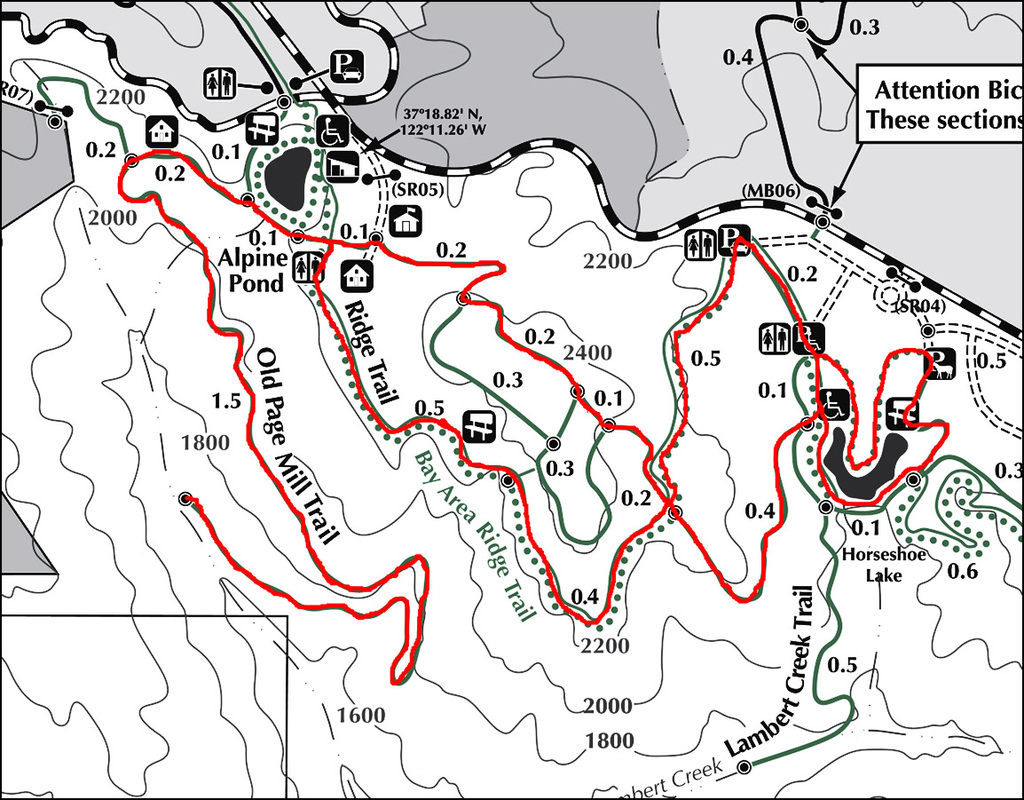
Before I start my description a comment about the park map and trail signs. You may have noticed on the map that most of the trails are not named. This is true for some of the signage on the trails. However, some of the trails are named differently between the map and signage. Fortunately the one thing that is clearly labeled on the signs are the destinations of the trails. This fact, and a map in hand, actually allowed for pretty good navigation of this loopy trail system. I do strongly suggest bringing a map with you to help out.
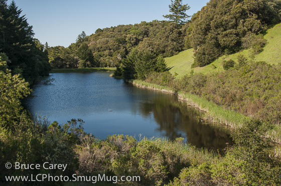
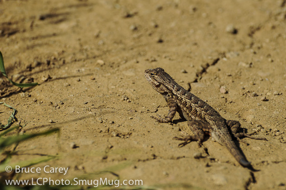
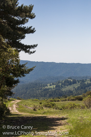
I began my hike with a loop around Horseshoe Lake (an aptly named "U" shaped lake). What a beautiful spot! If you follow the complete loop you pretty much see the lake from just about every angle possible. The trail ranges from being right at lake level to about a hundred feet above so there is plenty of variety. While there was not a lot of wildlife there the day of my visit I imagine, like most lakes, it can probably be quite lively at times. The walk around the lake is short, about 1.5 miles and not at all difficult so there are no excuses for not getting out and seeing this gem (the first part is even wheelchair friendly). The trail weaves in and out of Redwoods, Oaks and tall scrub. At the interior bottom of the "U" nestled in the redwoods about 100 feet up from the lake, the trail passes two picnic tables that I've got to say are probably one of the best spots for a picnic I've seen in a while! Since the loop returns you to it's starting point and the trail to see the rest of the park branches off the Lake loop, you have to re-walk the first tenth of a mile of the lake loop. Turn left onto this no-name trail when you get to the bridge and you head up into the hills through some tall scrub and Oaks At the first intersection I turned left onto what the map calls the Ridge Trail (called the Ipawii (spelling?) Trail on the signs on the trail). This single track trail follows along the ridge providing great views of both the redwood filled valley and hills as well as views of the coast. The mostly sunny section trail was a playground for lizards (and according to the signs rattlesnakes). In the latter section of this segment the trail gets a bit rocky as it cuts through some Manzanita and scrub. Eventually you end up at the Alpine Pond at the northern end of the OSP. From here you can loop back around on another trail (un-named on the map and I don't remember if it had a name or not but the signage is pretty specific about pointing you back the Skyline Ridge parking lot). However I had been intrigued by a nearby trail I saw on the map called the Old Page Mill Trail and decided to check that out. The Old Page Mill Trail is, I'm guessing, just what it says, an old extension of Page Mill Road. It starts as a somewhat maintained paved road for about .2 miles but after passing the Park Rangers residence the road has not been maintained and the paving is rapidly covered over with dirt and growing plants. This trail is not well maintained so I would only suggest taking it if you are comfortable with climbing over downed branches and trees crossing the trail. The width of the road is always present but in places the plant growth narrows the trail to a single track. I will say this, it is well worth the effort. For the full 2 miles it is mostly slow descent into the valley with the flora alternating between between dense redwood and oak/bayberry forests. At times the only sound is that of the breeze rushing through the needles of the redwoods (and the crunch of pine needles under your feet). There were several steep rocky ravines with stream beds in them (dry at the time I was there) that I imagine would be pretty dramatic in the rainy season. In fact the trail ends at a stream (with some water in it) and it's a great place to take a break. Since it's not a loop you head back up the trail. Though it's not a steep climb, it is more or less a steady uphill grind for about 2 miles. On reaching Alpine Pond I was pretty beat and hoping for some level ground. Unfortunately the level around the pond only lasted a short while and I had to endure some more pretty steep uphill climbing. After a brief stint through some of the service areas for the Forestry Service you end up in more Redwoods and open grasslands. The loop brings you back to an earlier intersection and you can return to the parking area the way you initially took or turn left onto the Ipawii Trail. That was my choice because I always like to cover new territory. This was a nice descent again through Oaks and Redwoods leading back the parking lot. Note: I have to admit this was a pretty tough hike. I intend on going back as the scenery was great. However I will probably not include the Old Page Mill Trail on this hike. It can be more reasonably accessed from Russian Ridge OSP. bc Alternate Route Turn Points and Descriptions |
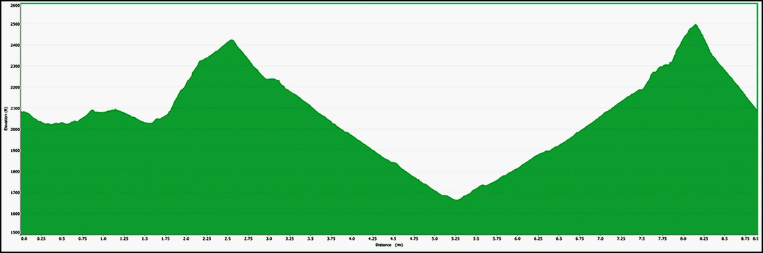
Elevation Profile