Terrain: From Flat to moderately steep. Steep sections are short with most elevation change being longer stretches of moderate change.
Trail Type: Single lane service road to single track. Mostly dirt, some gravel
Elevation Change: 500 ft.
Total Ascent/Descent: 1025 ft.
Cut-Off Points: Two that allow shortening the route.
Getting There
coming soon
Turn-By-Turn
Start on the Ridge Trail. Over the course of this trail you will come to several cut-offs that allow for shortening the route. Unless that is what you want you can ignore them.
When you reach Borel Hill turn right to reach the summit.
After descending Borel Hill the Ridge Trail splits into two alternate routes here (they are the same distance and end up at the same spot) to take the Valley View route turn right on the Ridge Trail. . I prefer to turn left, backtrack a bit and turn right on the alternate inland Ridge Trail.
Turn left to merge back with the alternate Ridge Trail route.
Turn left onto Hawk Trail.
Take the left fork at Alder Springs Trail which I think is staying on Hawk Trail (it could be merging onto Alder Springs trail).
Stay on this trail as you pass a cut-off back to the Ridge Trail by bearing left.
Turn left onto Ancient Oaks Trail at the Mindego Junction.
Stay on Ancient Oaks by bearing right at another cut-off back to the Ridge Trail.
Turn Right on the Ridge Trail.
Downloads
coming soon
Related Hikes
coming soon
Description and Map
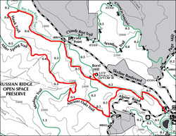
In an effort to get more hikes up in a shorter period of time I'm going to forgo the detailed description of this trail and concentrate on "Just the Facts". Since I have been hiking with a GPS for the last 4 or 5 years, and recording and saving the tracks from these hikes, I have a large stockpile of data on a lot of trails but only a limited memory of the details of those trails. I decided that instead of waiting till I can revisit this backlog of trails to refresh my memory on the details, it would be better to get the basic data posted ASAP since that will allow you to decide if the technical aspects of the trail are a match for what you are looking for. Of course I plan on revisiting this trail in the future so I will be adding a detailed description here when I do. Until then, here's what I remember...
Alternate Route Turn Points and Descriptions
There are two cutoffs that allow shortening the route (see map). The first yields a 3.5 mile hike, the second a 4.8 mile hike.
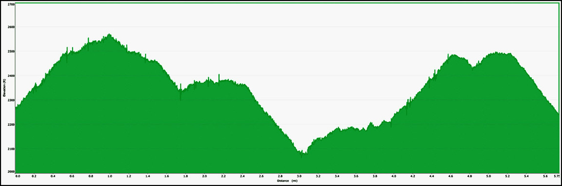