Mockingbird Hill Entrance - Short Hike
No photos from this hike posted yet but to see some photos from other hikes in this park go to: www.LCPhoto.SmugMug.com.
Hike Stats
Getting ThereFrom San Jose:
Turn-By-Turn
Downloads
Related Hikes
|
Description and Map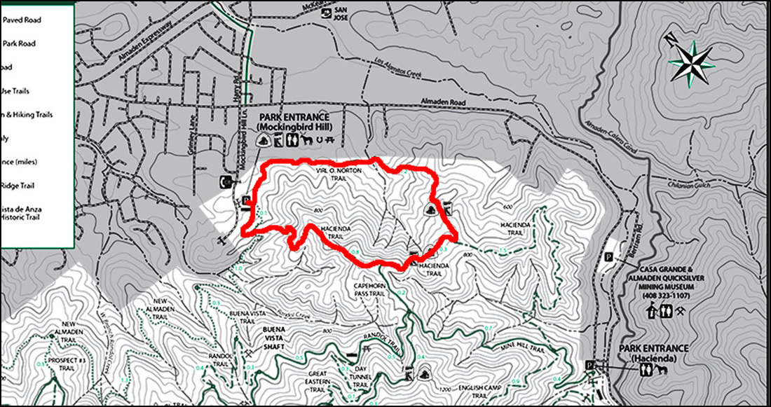
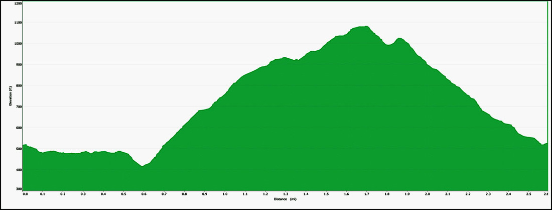
I suppose the first question many might have about this 2.6 mile hike is why do I consider it an intermediate hike. Take a quick look at the elevation profile at the bottom of the page and you'll see that other than the first .6 miles this hike is mostly pretty much steep up and then down with very little in between. Here are some stats. The ascent portion of the hike is a 1 mile grind at an average of a 12% incline. The steepest section of this incline is a .3 mile section of a 17.8% incline. Are you breathing hard yet? There is not much of a respite before the downhill starts. The descent is almost identical as the ascent clocking in at .9 miles and is at a -12.5% decline. The steepest section is a short 120 feet but is at a -30% decline (with fine loose soil over hard pack so footing is treacherous). So as you can see the elevation change is the determining factor here not the length of the hike. The good thing is that this is also an excellent hike for more advanced hikers looking for a quick workout. The trail starts at the Mockingbird Hill entrance parking area. I usually choose to start on the Virl O. Norton trail that starts on the left corner of the lot (kitty-corner from the restroom). Of course you can also do it in the reverse in which case you can start on either the Hacienda Trail or the New Almaden Trail. Taking the Virl O Norton trail the hike starts with about .6 miles of gentle slopes with the trail following the contours of the face of the foothills. On the left you get a fairly close view of the suburban developments in the Almaden Valley and to the right is the hillsides of the park. The trail winds it's way through alternating sections of sunny grasslands and shady Oak covered sections. At about the .6 mile mark that trail heads up. As I mentioned it's a pretty steady uphill 1 mile grind so you'll probably need to take a break occasionally to catch your breath. That's not altogether a bad thing as the higher you get the more panoramic the view of the Almaden Valley gets (I use the excuse that I want to check out the view rather than that I need to catch my breathe and you can use that one too if you want!). The stretches of alternating trees and grasslands continues though the sections get a bit longer and Bayberry trees are added to the mix with the Oaks. After about another .6 miles the Virl Norton Trail dead ends into the Hacienda Trail. On this hike you want to turn to the right onto the Hacienda Trail. (See Alternate Route Turn Points below) This section is a bit more "leisurely" in its .4 mile ascent to the peak elevation of this hike with steep sections alternating with not so steep to almost level sections. You get some great views of one of the interior valleys in the park and some more great panoramic views of the Almaden Valley with the backside of Santa Teresa County Park visible on the opposite side of the valley. If you look toward the left end of the valley you'll see some views of downtown San Jose. Just before you reach the highest point of this hike (about .3 miles) you'll come to the intersection of the Capehorn Pass Trail, just bear to the right to stay on the Hacienda Trail. The descent begins pretty much immediately after reaching the summit of about 1080 feet and is pretty continuously down all the way to the parking area. One caution, with the steepness of this descent and the fact that the trail is a hard packed dirt that can get a thin layer of fine dust and oak leaves care needs to be taken to avoid slipping. Take smaller steps than your normal stride and keep an eye on the condition of the trail ahead of you (this is where a good pair of hiking boots can come in real handy). The trail is in much more shade under Oaks and Bayberries with some nice views of of the Santa Clara Valley and the opening of the Almaden Valley. The final trail intersection is the New Almaden Trail. You can turn right onto the New Almaden Trail or continue straight on the Hacienda Trail. Both options are the same distance (about .1 mile) though I kind of think the New Almaden Trail is a bit more scenic. Alternate Route Turn Points and DescriptionsFor a considerably more demanding hike you can turn left on the Hacienda Trail. This alternate route more than doubles the length (6.7 miles) and also more or less doubles the elevation change so this is definitely a more advanced hike option. I haven't done this longer hike in a while but will document it in the advanced section when I do it again.
If you want to give it a shot here's the instructions.
|
Elevation Profile